Geologists have been drawn to the coastal area of the East Riding of Yorkshire, also known by the name of its greater part, Holderness, since the earliest development of the discipline, around the turn of the nineteenth century.
One principal theme of interest is rapid erosion of the clay cliffs, and indeed that is exemplified by the wording at the head of other pages appearing on this website. Another represents the opposite – the processes of deposition which formed the land in the first place. It is the latter that provides the subject here.
Among the first field studies of the cliffs was that conducted by John Phillips (1800-1874), then of York. (Specific measurement of cliff loss came later – see data in detail.) Phillips’ survey is included in his Illustrations of the Geology of Yorkshire, or a Description of the Strata and Organic Remains of the Yorkshire Coast, published in 1829.
The following passages from the text reflect the thinking of the time.
Of many important facts which come under the consideration of geologists, the “Deluge” is, perhaps, the most remarkable; and it is established by such clear and positive arguments...the deluge must be admitted to have happened, because it has left full evidence in plain and characteristic effects upon the surface of the earth [p16, italics as in the original].
Also:
There is, perhaps, hardly any district in the island [Britain], which displays in so striking a light the powerful effects of the deluge as Holderness [p48].
The deluge that Phillips refers to is the flood as narrated in the Bible (Genesis, Chapters 6 to 9). During the middle decades of the nineteenth century, with no small part played by Jean de Charpentier, Louis Agassiz, and Karl Friedrich Schimper (see origins), opinion was to turn in favour of glaciation. Not a deluge but massive sheets of ice once encroached upon the surface of the earth.
Phillips, in his later career, came to accept ‘ancient glaciation’ as an explanation.
Five major ice series have been identified throughout the last 2.4 billion years of Earth’s existence, and an earlier one proposed. Each would consist of a succession of glacial advances and retreats, and little movement at all, over long – perhaps very long – periods of time. The expression ‘Snowball Earth’ is sometimes used to hypothesise the most severe situations. (Earth has also experienced ages of ‘hot house’ conditions, seemingly devoid of ice. Climate change is part of the planet’s operation.)
The most recent of ice ages, beginning nearly 2.6 million years ago and technically considered to be ongoing, is characterised by comings and goings of ice that are better defined.
In the Britain Isles, the depositional record for the period is fragmentary to begin with. Glaciation, and subsequent erosion, can remove evidence of what went before. The greatest advance, the Anglian, lasted from around 475,000 to 425,000 years ago, when ice covered much of the country. Present-day coastal clays of Norfolk and Suffolk were laid down during this event.
Two further glacial stages came after the Anglian. These are called the Wolstonian (after a site in Warwickshire) and the Devensian (from the Roman name for a British people living by the River Dee on the Welsh border).
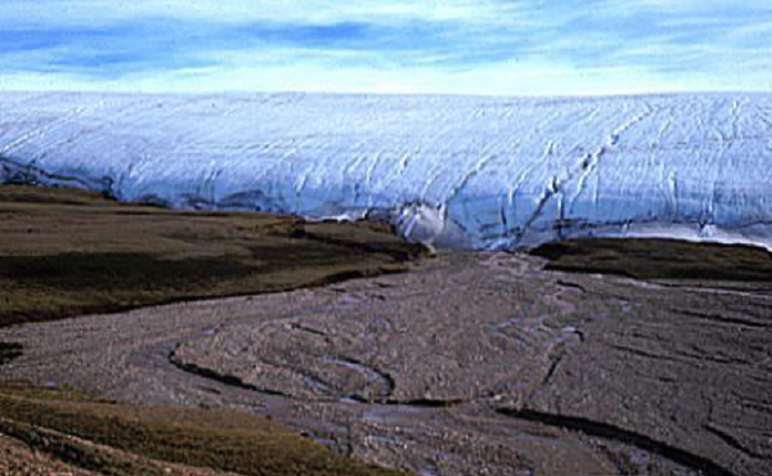
Glaciers like this have advanced from the north and retreated on a number of occasions, an idea first put forward in the early middle nineteenth century [source: glaciated landscapes].
Dates vary according to method of estimation. For present purposes, the Devensian stage opened some 115,000 years ago, following the Ipswichian interglacial, when temperatures were comparable with or slightly above those of today. As with other climatic cycles within the last million years or so, intensity of cold increased somewhat unevenly as the Devensian progressed, to reach the Last Glacial Maximum (LGM), about 30,000 years ago.
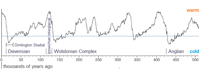
Comparative climate change over the last half million years [based on Railsback et al (2/2015) using MIS data]. The blue line suggests a threshold for glaciation in East Yorkshire.
The LGM, colloquially the ‘Ice Age’, is represented in Britain by the Dimlington Stadial – a stade, or stadial, being a cold phase. Dimlington is a Site of Special Scientific Interest (SSSI) in south Holderness. It was during the Dimlington Stadial that Holderness was created.
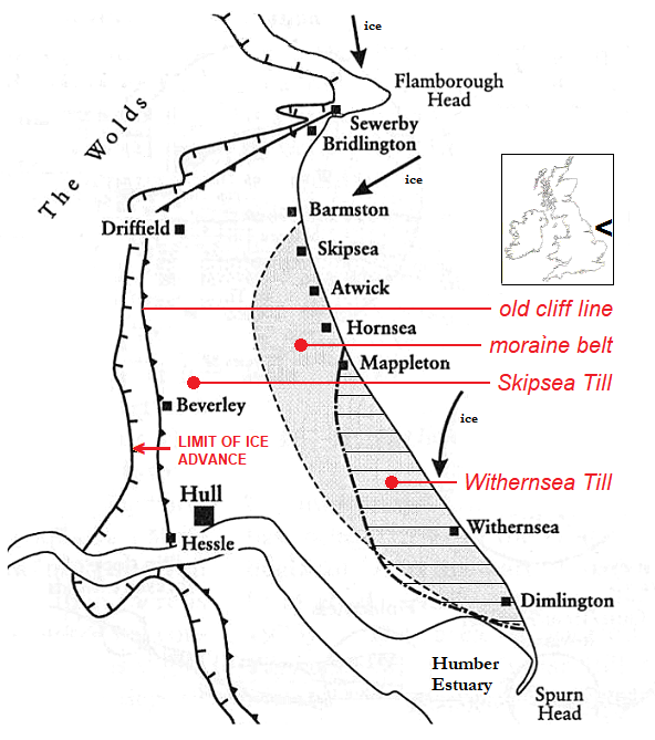
Dimlington Stadial ice advance limits [based on Huddart & Glasser (2002, fig. 5.29, p143), itself based upon Eyles et al. (1994, fig. 2, p729)]. Skipsea Till underlies the Withernsea Till. The moraine belt is a surface feature of both tills.
See also an ice age legacy.
Derived from an old Scottish word for rough stony soil, the term ‘till’ began to be applied to the clay debris of glacial withdrawal during the mid-1800s. Another name is ‘boulder clay’, once widely used but now rare.
The cliffs of East Yorkshire as seen especially from the beach provide access in the manner of a partial cross-section to the tills that form the land. William Sawney Bisat (1886-1973), who systematically surveyed the coast during the 1930s (and who produced a sketch over eight metres in length), established a tripartite sequence by introducing the name Drab to go with terminology used in the day, Purple and Basement.
Bisat’s system continued until a general revision of stratification in 1999, under which the Purple Clay, or Series, became the Withernsea Member of the Holderness Formation, and the Drab became the Skipsea Member. The Basement was recast as the Bridlington Member, though it is seldom seen at Bridlington, and the name is perhaps somewhat unrepresentative (in these pages the old name prevails).
The Skipsea fills the entire glacially deposited area. Part of it is overlain by the Withernsea. Beneath them, and resting on a buried chalk bedrock is the Basement, exposed mainly at Dimlington. Within the tills are different units, for example beds, resulting from advances, stillstands, and retreats of ice.
There was once thought to be a lesser till called the Hessle overlying all – more on this later.
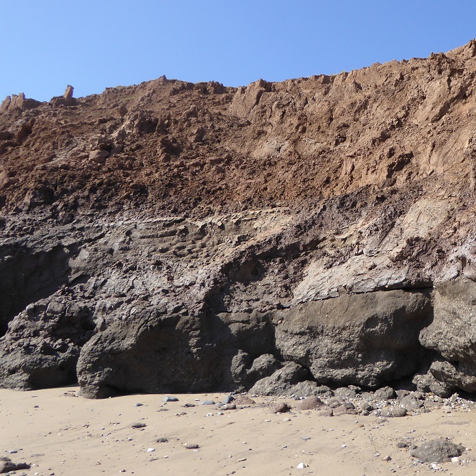
All three Holderness tills – top to bottom: Withernsea, Skipsea, Basement [Dimlington: 14 June 2023].
In the top of the Basement Till at Dimlington, small depressions can sometimes be found which contain laminated, or thinly bedded, silts. First recorded by Bisat, within the silts may be preserved remains of moss. Such organic deposits between tills indicate a less cold environment over an interval, and therefore a separation of glacial events, in addition to providing potential containment dates for the tills.
Penny et al (1969, p65) had samples of the moss analysed for radiocarbon dating (organic). Two samples, two occasions, taken from the same bedding plane, analysed in two laboratories using different methods.
The results were:
14C 18500±400 years BP (22,510 years ago)
14C 18240±250 years BP (22,327 years ago)
These 14C dates are ordinarily quoted within the literature. 14C refers to the carbon‑14 isotope on which testing is based. BP stands for Before Present, ‘present’ generally taken to be AD 1950. Calendar years are from own calculation. An outer range for the organics would be 22,970 to 21,862 years ago.
Samples of the silts were dated by Bateman et al (2015, p720) using optically stimulated luminescence (OSL, mineral), and the dates revised by Evans et al (2021, p19). Ranges are 21,200 to 20,500 (22,700 to 19,300 outer) and 23,500 to 22,800 (25,000 to 21,400 outer) years ago respectively.

Date ranges proposed for Dimlington intertill deposits (see text).
As might be expected from some two centuries of study, views have shifted on certain aspects of the tills. Similarly to how John Phillips (above) was sure about a mighty flood, a researcher of any period working with what is available within the various constraints of the time can cultivate and promote an idea that is not necessarily supported by later assessment. Three examples are given.
1. composite glacier or re-advance
Were the Skipsea and Withernsea tills delivered by a single composite glacier, one that originated as flows from separate ice centres before merging and continuing as a tiered body south along the western edge of the bed of the North Sea? Or does the Withernsea mark a re-advance of the Skipsea?
A geologist and soil scientist who argued the case for a tiered glacier, and defended it under challenge, was John Catt (1928-2017).
In Catt (2001: pp64-65), eight points are put forward, and in Catt (2007: p195), which is a comprehensive review of glaciations affecting East Yorkshire, seven points are presented. A point absent from the later assembly is that the short time period involved was ‘scarcely sufficient for two glacial advance and retreat episodes.’
Earlier mentions of the tiered hypothesis are found in Catt (1987: p98), and in Catt & Penny (1966: p394), where, using previous names:
...the Drab, Purple and Hessle Tills are here referred to the same glaciation, and it is suggested that they represent only one period of ice advance.
However, dates proposed for the Skipsea and Withernsea tills from more recent attention seem not to coincide.
Bateman et al (2011), in a paper which specifically addresses the matter, place an indicative age obtained by the OSL dating of sands interbedded between the two tills at around 16,200±400 years ago, with the tills either side [Conclusions, p582]. In their opinion, the outcome of the study:
...thus facilitate the replacement of Catt’s monoglacial ‘two-tier ice sheet’ hypothesis with one involving two separate oscillations. This conforms with the stratigraphic interpretation of Evans and Thompson [sic] (2010) [p581].
The Evans & Thomson paper, which utilises British Geological Survey borehole data from 146 locations, has this to say:
The initial advance of the North Sea lobe…resulted in the deposition of a westerly thinning advance till (Skipsea Till)…[the] retreat till (Withernsea Till/Member) records the most significant of the readvances of the North Sea lobe during its overall recession [Conclusions, p186].
Glacial advance and retreat dates were later revised, in Bateman et al (2015) and Bateman et al (2018). See chart at end.
Viewed from a newly informed perspective, the two-tier ice sheet hypothesis would appear to be irrecoverably weakened by the application of different dates to the tills. Questions nonetheless remain regarding the exact mechanisms of the period. Perhaps not all of Catt’s points can be said to have been completely resolved.
2. the age of the Basement Till
From the Abstract of a paper by Eyles et al (1994):
Amino acid analysis of marine mollusc valves show that the Basement Till of Holderness, Yorkshire, is of late Devensian age (ca. 20,000 BP) and not pre-Ipswichian (>125,000 BP) as is traditionally supposed.
Samples were collected from Dimlington. The ‘traditionally supposed’ age of the Basement Till mentioned in the abstract originated from observations at the Sewerby buried cliff site, investigated first by Clement Reid (1885: pp48-49) then examined in detail by George William Lamplugh, (1887). At this location, like Dimlington also an SSSI, the cliff line and beach that defined the coast during the Ipswichian interglacial turn inland, where both are covered by Skipsea Till.
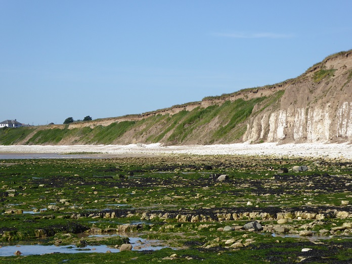
Sewerby, where the pre-glacial chalk cliff (at the right in the picture) continues inland [25 June 2018].
Lamplugh, who continued to report on the ‘ancient sea beach’, held that the Basement Till overlies the Ipswichian beach, meaning that it must be younger in age. Around the end of the 1880s, Lamplugh, otherwise an important contributor to the discipline, became a convinced monoglacialist, believing there had been only the one glaciation, albeit subject to fluctuation. The Ipswichian beach as an interglacial (i.e. between tills) feature rather than a pre-glacial one would have been inconvenient.
Catt & Penny (1966), on the other hand, assigned the Basement Till to a pre-Ipswichian glacial event because of its presumed truncation at Sewerby by the Ipswichian beach.
They say:
The relationship of the Basement Series to the buried cliff became apparent for the first time when, in 1963, it was exposed on the foreshore between Bridlington and Sewerby...Resting on the surface of the Basement Till, and adhering to it, were several patches of calcreted conglomerate composed of small, rounded chalk pebbles with a few flints and far-travelled rocks (also rounded)...
The conglomerate overlying the Basement Till in this foreshore exposure is similar to Lamplugh’s description of the [Ipswichian] beach shingle, except that at the cliff it was uncemented and the pebbles were larger.
We are confident that it is the seaward continuation of the shingle, and we therefore arrive at the important conclusion that the Basement Series is older than the [Ipswichian] beds...and must therefore belong to the Saale [Wolstonian] Glaciation or earlier [p387, paragraphed here for easier reading].
It is a reasonable conclusion but that does not make it a correct one. A lot is made to depend on a single piece of not absolutely proven evidence. Attempts to correlate the Basement with small deposits of till in County Durham and Lincolnshire do little to strengthen the case.
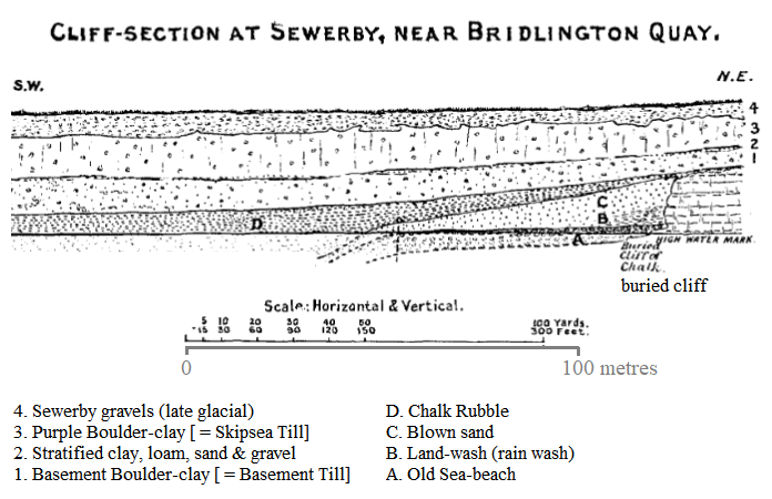
The situation according to Lamplugh (1903, p94). In the sketch, the Basement Till (1) is depicted above the old beach (A). The same till is shown rising to the top of the chalk. (Note the use at that time of Purple to describe Skipsea Till.)
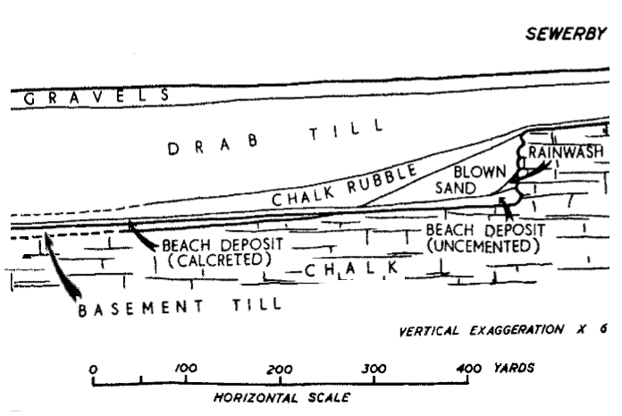
The situation according to Catt & Penny (1966, Fig.2, bet. pp388-389). A calcreted beach deposit lies on an exposure of the Basement Till, which terminates before it reaches the cliff. The calcreted deposit is depicted as being a seaward extension of an uncemented beach deposit at the cliff, associated with Lamplugh’s description of the old beach.
(The above two figures are cropped and slightly modified to fit the page.)
Unfortunately, the present-day fieldworker cannot visit and decide for themselves, since the relevant sections at the Sewerby site are simply not available.
Recent OSL tests applied to till from Dimlington have yielded a possible date of glaciation at 25,600±3,300 (28,900 outer) years ago (Bateman et al, presentation 2024). When this is considered along with the amino acid dating conducted by Eyles et al, which indicated a Late Devensian age, and the two are presented against the interpretation of a shingle deposit put forward by Catt & Penny, then a late Devensian age for the Basement Till becomes the more persuasive.
3. the rise and fall of the Hessle
The Hessle Till had a good innings.
According to Catt (2007, p178), the layer was:
...first noticed by Wood & Rome (1868), who recognised three latterly persistent clays (tills), which they named (in ascending order) the Basement, Purple and Hessle.
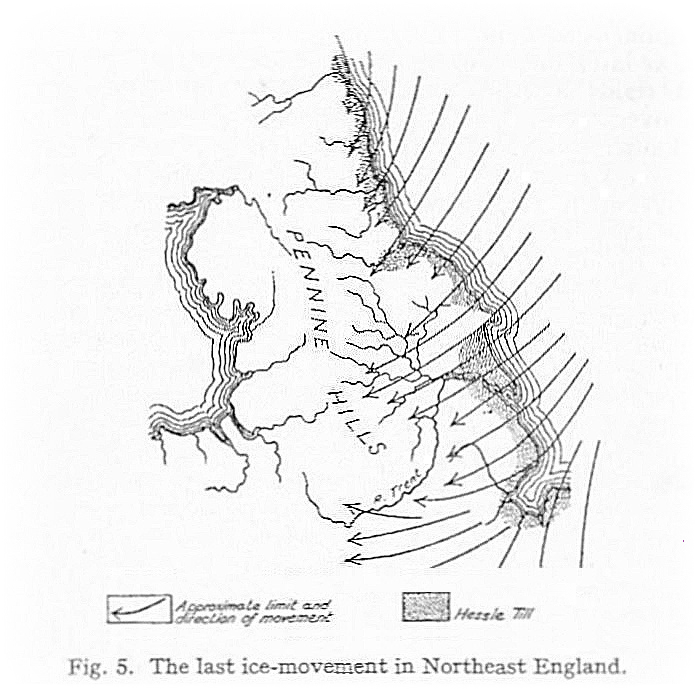
Deposition of the Hessle Till by a final ice sheet – one mid-twentieth century view [Carruthers (1948: p154)].
Catt & Penny (1966) were certain as regards identification.
The uppermost till seen in the cliff sections is the Hessle. This varies in thickness from five to fifteen feet, but in a few places has been removed or partly removed by later erosion. It is undoubtedly a distinct entity within the Drab-Purple-Hessle Series, having a characteristic erratic suite [p392].
...
It is clear…that Wood and Rome’s picture of the Hessle Till lying ‘like a cloth’ over the whole area is broadly correct, for wherever till is exposed at the surface or immediately beneath post-glacial deposits in southern Holderness, it is the Hessle [p393].
A little over a decade later, a change of mind and a clean sweep were announced. Madgett & Catt (1978) wrote:
Our main conclusion, that the Hessle Till is a composite unit, weathered Purple Till in south-east Holderness and weathered Drab elsewhere invalidates a lithostratigraphic term which has been widely used for over a century. We suggest that use of the name ‘Hessle Till’ should be discontinued [p90].
And so the once ubiquitous Hessle was gone.
In an account of glaciations and interglacials, the blackboard analogy will serve. A lesson is written on the board in a classroom. Later, the board is wiped sufficient for a new lesson to be put up. And so on. At the end of the day, can anything possibly be deduced about the various lessons? The tills that Holderness retains identify only the last session.
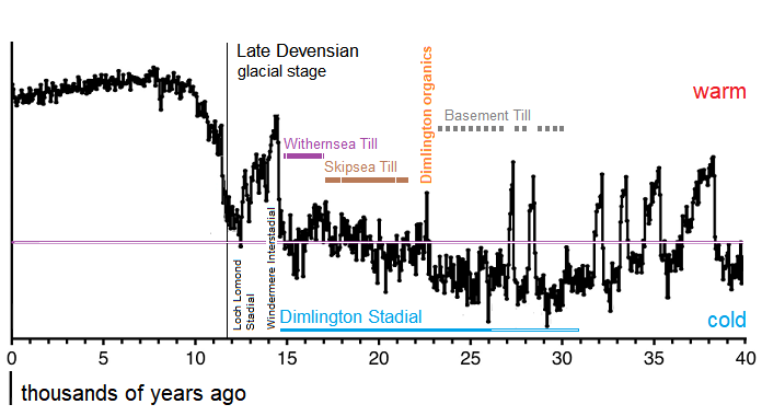
Late Devensian deposition of till in East Yorkshire, compiled from recent estimates [graph based on Railsback (2013) using NorthGRIP data].
Age ranges for the Withernsea and Skipsea tills continue to be adjusted as dating techniques are refined. Enough information exists for outline purposes.
On the above chart, the Basement Till is shown as an intermittent bar made to coincide with troughs falling below the suggested threshold for possible glaciation.
Traces may linger of till from pre-Devensian ice sheets within cracks and clefts in the chalk bedrock. The Anglian glaciation blanketed the subject area including the Wolds, where erratics are reported (but no till deposits), and glacial features are observed.
At least for the present, the idea of a proto-Holderness, of till filling the bay as a result of the Anglian or Wolstonian glaciations – or indeed any that preceded these – to be eroded during subsequent interglacials (a process that is observed following the Dimlington Stadial), must remain an exercise of imagination.
further reading and references
East Yorkshire coastal erosion pages index
Prepared by Brian Williams, 2023/2024.


